Overview of the Annapurna Circuit Trek Route
The Annapura Circuit Trek is one of most iconic and rewarding trekking journey in Nepal. This Himalayan adventure covers a total trekking distance of 160 to 230 km (100 to 142 miles). depending on where you start and finish. The trekking distance will also be majorly impacted by the optional side excursions like Tilicho Lake or Ghorepani.
Traditionally, the trek begins at Besisahar or further up on the trail at Dharapani and ends at Jomsom, Tatopani, or even Nayapul, depending on the trek extension and walking plan in your itinerary. Most trekkers complete this journey in a span of 12 to 20 days. The total lenght will depend on your pace, acclimatization and route choice determine the overall duration.
The shorter variation, 10 Days Short Annapurna Circuit Trek is another ideal itinerary plan for trekkers who are on tight schedules and want a complete experience without missing out on anything. To trek this circuit route, you will need two permits: the Annapurna Conservation Area Permit (ACAP) and the Trekker’s Information Management System (TIMS) Card.
Understanding this general structure is key to planning this iconic experience effectively, whether you are doing the entire loop or blending it with off-road transports and side extensions.

|
Total Trek Distance
|
160 to 230 km (100 to 142 miles)
|
|
Typical Duration
|
12 to 20 days
|
|
Starting Point
|
Besisahar or Dharapani
|
|
Ending Point
|
Jomsom, Tatopani, or Nayapul
|
|
Highest Elevation
|
Thorong La Pass (5,416/ 17,769ft)
|
|
Recommended Direction
|
Anti-clockwise (for safer altitude gain)
|
|
Necessary Permits
|
- Annapurna Conservation Area Permit (ACAP)
- Trekker’s Information Management System (TIMS) Card
|
Detailed Route Map Breakdown
The map of Annapurna Circuit Trek is not just about the distances. It also reveals the everyday elevation pattern, trail forks, road segments, landscape details and also the hidden gems of the region. Here is a section-by-section breakdown of the classic anticlockwise route to help you interpret and use your map more efficiently.
Section 01: Dharapani to Chame (Lower Marsyangdi Valley)
This section of the Annapurna Circuit Trek route map marks the real beginning of this circumnavigating journey. After entering the Annapurna Conservation Area at Dharapani, the trail starts to weave across the lower Marsyangdi Valley.
You will trek alongside the Marsyangdi River and cross several suspension bridges. This section is marked by lush woodland and you will pass traditional mountain villages that reflect both Gurung and Tibetan-Buddhism-influenced culture.
This stretch passes across many beautiful villages such as Timang, Thanchok and Koto to Chame, the administrative hub of Manang District.
Map Tip: Study the terrain structure, villages and river crossings. The Annapurna Circuit map shows a fork at Koto where a side trail leads to Nar Phu Valley, which is an isolated and restricted region that requires special permits to access.

Section 02: Chame to Manang (Transition Zone)
After leaving Chame, you will enter one of the most scenic segments in the Annapurna Circuit Trek route. The trekking trail follows the valley floor more closely and is flanked by the towering ranges like Annapurna II and Lamjung Himal.
You will trek across Bhratang Village and Dhikur Pokhari to eventually reach Lower Pisang. The trail on the Upper Pisang route then steeply ascends through Ghyaru and Ngawal Villages, offering panoramic views of the Annapurna range and Marysangdi Valley below.
After rejoining the main trail at Braga, the trail gently climbs toward Manang. This is a major settlement in the Annapurna Circuit route and offers many modern amenities to travelers.
Map Tip: Choose the Upper Pisang route on your map for better views and more effective altitude gain before heading toward the pass. You may also mark a side trip to Ice Lake (Kicho Tal) or Gangpurna Lake, both of which are ideal acclimatization hike destinations.

Section 03: Manang to Thorong La Pass
This is the core section of the Annapurna Circuit and it is where the maps become crucial for elevation planning and safe acclimatization. Leaving Manang, you will move along the arid landscape, where the trees are replaced by wide pastures.
The trail gradually climbs to Yak Kharka and then toward Ledar,both of which are small settlements with basic teahouses. From there, the path narrows down as you head toward Thorong Phedi, the base of the pass.
Some trekkers sleep here while others push themselves on one more steep stretch to climb to High Camp for a shorter summit day. The ascent on Thorong La Pass begins before sunrise to avoid strong winds and this is the most physically demanding segment of the Annapurna Circuit Trek route map.
The pass itself is marked by prayer flags and a signboard, which is often covered in snow depending on the season. After crossing the pass, you will descend steeply toward Muktinath, a sacred pilgrim site for both Hindus and Buddhists.
Map Tip: Study the elevation profile on your map carefully. It will help you space your day and avoid ascending too quickly in the high-altitude route. Many maps also show side trails to Tilicho Lake, which can be merged with the main route before Yak Kharka.

Section 04: Muktinath to Pokhara
After crossing the pass, for the descending section, you will enter the Lower Mustang region. The landscape here is drier, windier and culturally Tibetan. From Muktinath, your descent takes you to Kagbeni, or you can head straight to Jomsom, the district headquarters.
From Jomso, you have the option to take a flight or a jeep to Pokhara. Or you can continue on the trekking route from Marpha to Kalopani to Tatopani to Ghorepani to Nayapul in an extended itinerary plan.
Map Tip: A proper map will help you identify the walking trails that avoid roads, especially between the Jomsom and Tatopani sections. Look for New Annapurna Trekking Trails (NATT) markings on the modern map, as old maps only show the motor road.

Alternative Routes and Side Teks on Annapurna Circuit Trek Map
While the classic Annapurna Circuit is impressive on its own, a detailed map reveals a network of less-traveled trails and side trips. By understanding this, you can enjoy one of the most flexible and rewarding trekking experiences in the world.
These extensions will appear as branching trails or dotted lines on most map of Annapurna Circuit Trek. If you have time and strength, adding these side trips to your trek will elevate the experience both physically and emotionally.
Tilicho Lake Via Siri Kharka
From the vibrant town of Manang, instead of heading directly toward Yak Kharka, the Annapurna Circuit Trek map shows a branching trail to the west. The route passes across Khangsar and then ascends steadily to Siri Kharka.
The trail then climbs sharply on the narrow stretches and landslide-prone sections toward Tilicho Base Camp. Most trekkers stay here for the night and push to Tilicho Lake before a pre-dawn. The final ascent on this trail is slow but spectacular; the approach to the lake includes a steady ascent through loose scree and exposed slopes.
Upon arriving at the lake, the first noticeable feature is the size and altitude of the lake. Tilicho Lake spans across 4 km (2.4 miles) in distance and is considered one of the highest lakes of its size in the world. The water of this glacial lake is often frozen, depending on the season and its surface reflects the surrounding Himalayan massifs like Tilicho Peak, Nilgiri and Khangsar Kang.

Why TIlicho Lake Extension Is Valuable?
- The landscape between Siri Kharka and TIlicho Lake is unique; it introduces you to high-altitude alpine terrain, glacier-carved valleys and massive vertical rock faces
- Spending time above 4,000 meters before crossing Thorong La Pass gives you an acclimatization advantage
- Unlike the main circuit route, the Tilicho Lake extension is less trafficked
- Tilicho Lake has geographical significance in the Annapurna region’s glacial system
- For serious trekkers, the demanding section of Tilicho presents an opportunity to push physical limits and test high-altitude readiness
Ghorepani Poon Hill Extension
The Ghorepani Poon Hill is another beloved Annapurna Circuit Map extension. It is one of the most practical and scenic ways to conclude this circuit journey. This Ghorepani Poon Hill extension brings trekkers through the lush forested lower foothills of the Annapurna range and end with panoramic views of the Himalayan range from one of the most popular viewpoint in Nepal, Poon Hill.
After crossing the Thorong La Pass, most trekkers descend to Jomsom or Tatopani. Then, from Tatopani, the trekking route gradually winds through charming villages of Gharkhol, Sikha and Ghorepani, passing through dense rhododendron and oak forests, terraced farmlands and river valleys.
From Ghorepani, one of the major Gurung and Magar settlement of Annapurna, trekkers can hike to Poon Hill. This world-renowned viewpoint rewards you with striking views of Dhaulagiri, Annapurna South, Hiunchuli, Machhapuchhre and Annapurna I.
Why Ghorepani Poon Hill Extension Is Valuable?
- One of the most photographed sunrise viewpoints in the Himalayas
- A scenic closure with return to greenery and biodiversity
- Opportunity to experience the ethnic diversity of Nepal
- A gradual descent instead of abruptly ending the trek by off-road drive or flight
- Flexible exit point, trekkers can exit from Nayapul, Ghadruk, or Kimche
- Accessibility for mixed groups with varying physical abilities or timeframes
Annapurna Base Camp Connection
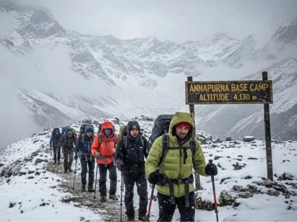
The Annapurna Base Camp connection is another highly rewarding extension to this circuit trek. This addition is most suited for trekkers who want to extend their trek into the central core of the Annapurna Massif.
While the Annapurna Circuit Trek takes you around the outer rim of the range, the ABC route delivers a direct approach into the heart of the Annapurna Sanctuary. You will stand at a glacial amphitheater surrounded by the towering 7,000 and 8,000-meter peaks.
You can add this extension to the map of Annapurna Circuit Trek after descending from Thorong La Pass and while moving southward through Tatopani or Chhomrong. This way, the journey will feel seamless and trekkers can give continuation to their journey toward the high-mountain base camp.

Why Annapurna Base Camp Connection Is Valuable?
- A direct access to the heart of the Annapurna range, you will trek to the foothills of the range for a full-scale mountain immersion
- Accessible glacial and alpine terrain without extreme altitude, Annapurna Base Camp (4,130m/ 13,549ft)
- Diverse contrast in terrain, from high-alpine basins, cascading waterfalls, to bamboo groves and steep river valleys
- A stronger and more memorable finish compared to road exits
- Ideal addition for multi-landmark exploration, an opportunity to traverse both outer and inner Annapurna regions
Using the Map for Trek Planning
A detailed and up-to-date Annapurna Circuit Trek route map is an essential tool when planning this iconic circuit trekking journey. You will need a detailed and quality map to understand the length, elevation variation and number of route alternatives and available extensions in this circuit route.
Take the map as a critical resource for building and planning a realistic, efficient and safe itinerary plan for your journey that matches your fitness, time frame and goals.
- Identifying Key Waypoints and Staging Your Days: To efficiently use the Annapurna Circuit Map, start by identifying the major villages and logical overnight stops along the way. In the map, these major settlements along the way are mentioned in bold names, elevation markers and an icon indicating lodges or amenities.
- Designing a Flexible Day-by-Day Itinerary: Once you have understood the village's location along the circuit trek route, use the map to understand the distance and elevation chart at each point. This will help you plan acclimatization, buffer days, side trips and understand daily distance vs difficulty.
- Mapping Out Safety Zones and Risk Sections: Proper planning is also about preventing risk or troubles along the way. If you have a quality map, you will find avalanche zones, landslide-prone areas, river crossings and remote sections properly marked. These are crucial when planning your day on the mountain.
- Planning for Alternative Routes and Re-Routing: Your map isn’t static; you can use it dynamically in response to the trail conditions. For instance, you can decide on the trek starting point or even fly out from Jomsom post trek. Likewise, if you have energy, you can also plan side extensions like Ghorepani or ABC.
- To Plan Resupply and Rest Points: Unlike other remote parts of the Himalayas, the villages in the Annapurna region are well-distributed, but not evenly. A quality Annapurna Circuit Trek route map indicates teahouse density, rest points, water stations, food zone, etc.
- Visualizing Terrain and Weather Exposure: A good map shows vegetation changes, terrain shading and overall topography. This will help you prepare gear and essentials to carry and at which zone you can expect warmth, cold, or snow.
Digital Maps vs. Paper Maps
In this digital world where smartphones and satellite phones have taken over the world, it is tempting to think a paper map is outdated. But when you are traversing across high passes or hiking through cloud cover in remote valleys with no signal or power, the old school map might be the thing that saves your trek.
Let’s break down the pros, cons and real-world use cases for both digital maps and paper maps on the Annapurna Circuit.
Digital Map: Power, Precision and Portability
Advantages
- GPS tracking; apps like Maps.me, Gaia GPS or AllTrails can show real-time location on trail
- Most digital maps allow you to download the entire Annapurna region, so you can access it without an internet connection
- Many apps show distance, altitude gain, elevation graphs and estimated walking time per segment
- Custom route planning option; you can freely mark or pin highlights, teahouse, or water points and even share the route plan with guides or friends
- You don’t need to carry extra weight in your backpack; everything is on your phone
Limitations
- Digital maps are battery dependent; cold temperatures, multi-day use and high brightness drain battery fast
- Limited details in remote areas, digital maps often don’t label lesser-used side trails
- In narrow valleys or dense forests, GPS signals can lag or lose precision
Paper Maps: Durable, Visual and Power-Free
Advantages
- No battery, no boot time, no charging needs; always on and never dies
- Paper maps let you see the entire circuit in one view, which is very helpful in understanding the terrain
- Greater details in terrain and topography; a high-quality Annapurna Circuit Trek itinerary map shows contour lines, elevation gradients, dangerous zones, vegetation areas, teahouses, water stations, etc
- Useful for route sketching and changes, you can mark your trail, add weather notes, or alter your route manually when plans change
Limitations
- Unless laminated or protected in a zip bag, they can tear easily or get soaked in rain
- The real-time tracking feature is missing; you need to be good at reading the terrain and identifying landmarks
- If you are using an older map, it may not show recent road construction or detours
So, in conclusion, digital maps give you power, speed and navigation support while paper maps give you clarity, confidence and long-term safety. On a trekking journey as diverse and as demanding as Annapurna Circuit, relying on both guarantees you will never get caught off guard, regardless of weather or terrain.
Map Reading Tips for Trekkers
- Always check the scale first to estimate walking distances accurately
- Identify and highlight the key villages along the trail before the trek
- Pay attention to the contour lines; close lines mean steep terrain and widely spaced lines mean flat or gradual slopes
- Use the elevation profile side by side to visualize altitude gain and plan acclimatization days
- Carefully study the trail junction or fork icons, which show where trails split and you will be able to avoid wrong turns
- Track daily distance and altitude gain together
- Circle the danger zone and plan an early crossing to avoid overnight stops in such areas
- Learn to understand symbols for water resources, lodges, food, and medical posts
- Cross-reference the physical map with GPS to confirm your live location


