Annapurna Circuit is one of the most celebrated trekking routes in the world. Annapurna draws thousands of adventurers every year to explore Nepal’s Himalayas. It is famous for its extraordinary diversity of landscapes, cultures, and climates, all combined into a single route that loops around the Annapurna massif. Starting from rice paddies and subtropical forests and moving forward up alpine meadows and barren high-altitude deserts, this trail offers you a constantly changing backdrop that will keep you engaged from start to finish the circuit.
After hearing about this iconic trekking route, everyone wonders, ‘How high is the Annapurna Circuit?’ They're usually referring to the highest point reached on the trek, which is Thorong La Pass. This is a dramatic mountain pass that sits at 5,416 meters (17,769 feet) above sea level, making it one of the highest trekking passes in the world. Moving ahead through this circuit is a physical and mental challenge, but it's also a highlight that many hikers consider as the ultimate achievement of their journey.
While the elevation at Thorong La is the trek’s most famous statistic. The route as a whole covers a range of altitudes from under 1,000 meters in the low valleys to over 5,000 meters at the pass. Massive variation like this is what makes the Annapurna Circuit unique. Not just about the height, but actually about the transitions between ecosystems, cultures, and climates that occur along the way.
Geographic Overview & Trek Length
Annapurna Circuit winds through central Nepal and encircles the Annapurna mountain range in the Himalayas. The trekking route lies within the Annapurna Conservation Area, which is the country’s largest protected region, covering 7,629 square kilometers. Walking on the route, you will experience huge different environments which start in lush river valleys before climbing into alpine terrain and eventually crossing through the arid rain-shadow region of Mustang.
This trek is not a single fixed route, but it varies depending on the chosen start and end points, including the side trips. Some of the certain sections of the trail are traveled by road or on foot. Traditionally, the full loop was about 230 kilometers (145 miles) and it would take 18–21 days. Nowadays, the development of motor roads in the lower sections and many itineraries now range from 160 km above. You can complete the trip in 12–16 days without losing the exciting experience.
The journey of this trip basically begins from the Marsyangdi River Valley on the eastern side and ends in the Kali Gandaki River Valley to the west. This east-to-west direction is preferred because it allows gradual altitude gain while reducing the risk of altitude sickness when you approach Thorong La Pass.
While looking at it geographically, the Annapurna Circuit offers you a living textbook of Himalayan topography. In just two weeks, you can pass through subtropical jungle, terraced farmland, pine forests, high alpine meadows and stark mountain deserts. These varieties are not only visually stunning but they also provide you with cultural richness and each zone is home to distinct communities and traditions.

Thorong La Pass - The High Point of the Trek
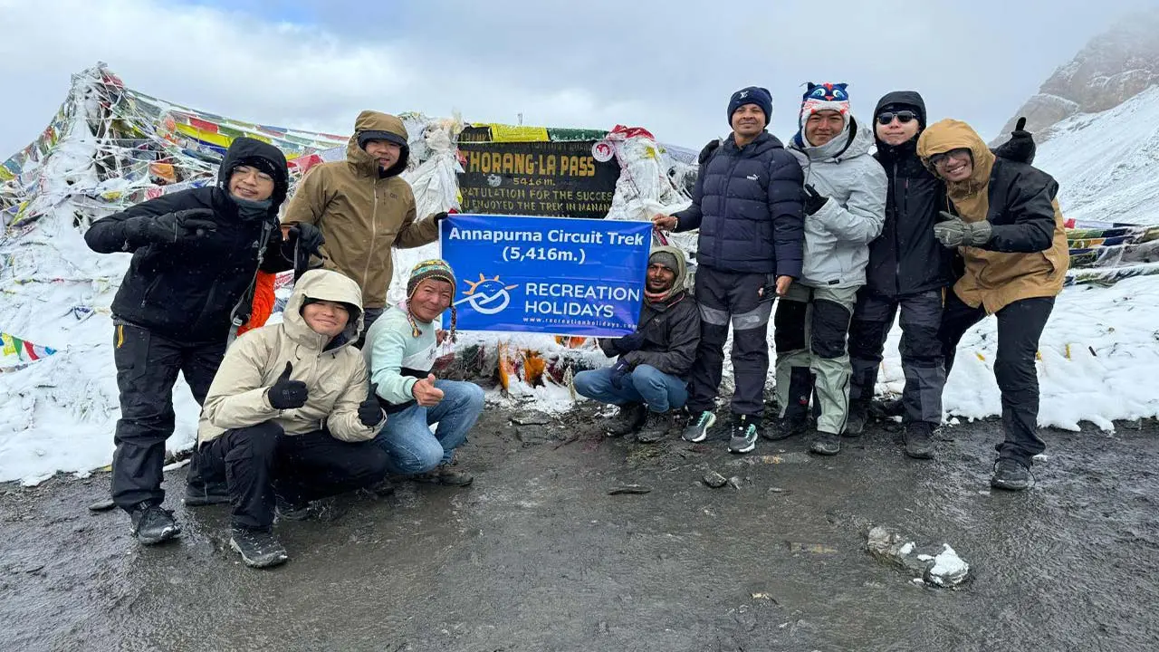
The heart of the Annapurna Circuit is Thorong La Pass, which is the trek’s highest point, also one of the most renowned mountain passes in the Himalayas. It stands at 5,416 meters (17,769 feet) above sea level, which marks both a physical challenge and an emotional climax for trekkers.
Thorong La connects the Manang Valley on the east with the sacred town of Muktinath in the Mustang district on the west. It is located between two significant peaks, Khatung Kang (6,484 m) and Yakawa Kang (6,482 m) and these add to its dramatic profile. Crossing the pass is not just about endurance but actually reflects preparation, acclimatization, and timing.
Most trekkers begin the ascent from Thorong Phedi (4,525 m) or High Camp (4,880 m) in the early hours before sunrise. This early start is very beneficial to avoid strong winds and potential weather changes, which make the crossing dangerous. The climb to the pass can take 3–5 hours, mostly on snow-covered or icy trails, which are followed by a long descent to Muktinath (3,800 m).
The view from Thorong La is unforgettable and breathtaking, a sweeping panorama of Annapurna II, Gangapurna, Dhaulagiri, and the surrounding peaks. A small chorten (Buddhist stupa) and strings of colorful prayer flags denote the spot while fluttering in the high mountain winds. For many trekkers, standing here represents the fulfillment of planning from many months ago and a lifelong trekking dream that has been conquered.
Itinerary Part 1: Lower and Mid Sections of the Trek
Annapurna Circuit starts with a gradual ascent from the lower valleys, which offers trekkers an opportunity to immerse themselves in Nepal’s vibrant rural life and diverse landscapes. From the capital city Kathmandu (1,345 m), where most travelers first take an 8- to 9-hour scenic drive to Dharapani (1,860 m), which is the typical trailhead. This journey follows the Marsyangdi River through terraced fields, small villages, and dense forests, while setting the tone for the trek ahead.
The trek properly starts from Dharapani with a moderate climb to Chame (2,610 m). The 5–6-hour walk takes you through pine forests and rhododendron groves, together revealing the rich biodiversity of the Annapurna Conservation Area. Chame is the district headquarters of Manang, which is a well-developed village where trekkers rest and prepare for higher altitudes.
From Chame, the route gains elevation more rapidly as trekkers head to Pisang (3,300 m). The trail navigates along ridgelines, which offer spectacular views of Annapurna II and the other surrounding peaks. Along the way, the landscape begins to change from dense forest to alpine meadows, which are dotted with prayer flags and traditional stone houses.
The next day’s journey starts from Pisang to Manang (3,540 m), which takes you around 5–6 hours. Manang is a crucial acclimatization stop well known for its hospitable lodges, teahouses, and breathtaking views of Gangapurna and Tilicho peaks. This middle section of the circuit equally balances the challenging climbs with cultural encounters and natural beauty together and prepares you for the higher elevations ahead.
Itinerary Part 2: High Section and Descent
After acclimatizing in Manang, you can embark on the demanding high-altitude portion of the Annapurna Circuit. The journey continues from Manang to Yak Kharka (4,060 m), which is a 4–5-hour trek that climbs through rugged alpine terrain and sparse vegetation. Yak Kharka serves as a gateway to the final approach to Thorong La Pass, offering you breathtaking views of snow-capped peaks and glaciers.
On the next day, the trek advances to Thorong Phedi (4,525 m), which is often called the last base camp before the pass. This 4–5-hour hike is physically demanding for you as the thin air and steep trail require careful pacing. Staying here allows trekkers to rest and prepare for the dangerous early morning crossing.
The key challenge is the Thorong La Pass itself, situated at 5,416 meters (17,769 feet). Trekkers usually start before dawn to avoid afternoon winds and changing weather. The ascent takes around 3–5 hours on often icy or snowy paths. Reaching the pass, hikers will be rewarded with panoramic views of Annapurna, Dhaulagiri, and the Mustang region, including the fluttering prayer flags and a serene Buddhist chorten.
After summiting, the trail descends steeply to Muktinath (3,800 m) then a sacred pilgrimage site known for its ancient temple and natural springs. The descent can take 4–5 hours and offers you a change in landscape from alpine deserts to dry and rocky terrain.
From Muktinath, many trekkers continue by jeep or foot to Jomsom. Then, from the vibrant bazaar, you can drive to Pokhara, which descends further to 827 meters. After that, the trek either ends at Pokhara or follows a drive across scenic valleys back to Kathmandu.
Elevation Flow & Terrain Changes
The defining features of the Annapurna Circuit are dramatic elevation gain and loss, which create an ever-changing landscape and trekking experience for the trekkers. Starting from around 1,800 meters in the lower valleys then the trek gradually ascends to the highest point at Thorong La Pass, which is 5,416 meters, before descending again to around 800 meters in Pokhara.
The trek begins in lush subtropical valleys where you can enjoy terraced rice fields, vibrant forests, and warm weather prevails. The lower sections between Dharapani and Chame are dominated by dense pine and rhododendron forests, also home to many diverse flora and fauna. These forests offer you a green canopy and moderate hiking conditions.
As you climb above 3,000 meters heading toward Manang and Yak Kharka, you can view the vegetation gradually thin and transform to alpine meadows dotted with wildflowers and hardy shrubs. The air becomes noticeably thinner, and temperatures gradually drop, especially at night time. This mid-altitude zone is characterized by traditional Tibetan-style villages with prayer flags fluttering in the mountain breeze.
Beyond Yak Kharka toward Thorong La, the landscape becomes stark and rugged. Here, you can observe alpine deserts with rocky terrain, sparse vegetation, and snowfields. The air is thin, and weather conditions become harsh, which demands proper acclimatization and preparation from the travelers.
Descending into the Mustang region after the pass, the terrain shifts to a dry, rain-shadow environment with rocky gorges, arid hillsides, and unique cultural influences. The landscape opens up again into greener valleys as the trek finishes in Pokhara, providing a lush contrast to the high mountain deserts. This continuous elevation shift and terrain diversity not only challenge trekkers physically but also enrich their sensory experience of the Himalayas.
Acclimatization and Safety Considerations
The Annapurna Circuit crosses high-altitude terrain, which peaks at 5,416 meters at Thorong La Pass. So, proper acclimatization is essential for both safety and enjoyment. Altitude sickness, or Acute Mountain Sickness (AMS), may affect anyone without regard to fitness, so gradual ascent and listening to your body are necessary.
The itinerary also includes your planned rest days, especially in Manang (3,540 m), which is a crucial acclimatization stop. During this day, you can explore nearby attractions such as Gangapurna Lake or Ice Lake while allowing your bodies to get adjusted to lower oxygen levels. Pausing like this helps to reduce the risk of headaches, nausea, and fatigue, which are associated with AMS.
You should trek slowly, avoiding rapid altitude gain above 300 - 500 meters in a day. Also, you need to stay hydrated with balanced nutrition, and avoiding alcohol is very important as well, it affects the acclimatization process. Guides often carry oxygen and first aid kits and experienced operators monitor trekkers closely for faster rescue for any incident.
Weather conditions can be so unpredictable at high altitudes. You can experience sudden storms, cold temperatures, and snow are common near Thorong La. Mostly in colder months, early starting to cross the pass is mandatory for every trekker to avoid afternoon winds and potential avalanches.
Emergency evacuation options exist via helicopter from remote points, but these can be costly and weather-dependent. So, as you know that prevention is better than cure, understanding the symptoms of AMS and descending immediately if the symptoms worsen is the safest course.
In summary, you should have respect for altitude, proper pacing, and awareness; then only you can make the Annapurna Circuit a rewarding and safe trek if you are willing to face the challenges of the high Himalayas.
Best Season and Weather Challenges
Proper timing is necessary for your trek on the Annapurna Circuit, which is essential for both safety and enjoyment. The region experiences two primary trekking seasons: spring (March to May) and autumn (September to November), which offer you the best weather, stable skies, and pleasant temperatures. Spring brings blooming rhododendrons and wildflowers along the lower and mid sections of the trail, alongside clearer views of the snow-capped peaks.
Temperatures gradually rise after the cold winter months, making this a favorite time for trekkers. Autumn is the most popular trekking season because after the monsoon rains end in September, you can enjoy clear skies, dramatic landscape, comfortable temperatures and crisp panoramic mountain vistas. The days are warm but not hot and nights can be chilly, especially at higher elevations.
The monsoon season (June to August) is generally avoided by many travellers because of heavy rain, slippery trails, which increases the risk of landslides and flooding. The circuit’s rugged topography means some days you might see unpredictable weather even in good seasons.
Winter months (December to February) bring the cold temperatures, mostly above 3,500 meters. Snowfall is common near Thorong La Pass, which makes the crossing more difficult and sometimes it becomes very dangerous. Trekking in winter, you should have more specialized gear and experience.
Still, even in peak seasons, unpredictable weather changes can affect the high altitude regions, including afternoon storms, high winds, and rapid temperature drops. Trekking companies recommend an early morning start to cross the high pass and constant monitoring of weather forecasts. Planning your trek around these seasonal patterns will ensure you safer passage, better trail conditions, and an amazing experience of the Annapurna Circuit.

Cultural Experience on the Annapurna Circuit
Behind its natural beauty and dramatic elevations, the Annapurna Circuit is an amazing journey through a mosaic of cultures, traditions, and religions, which enrich every step of your trek. The route passes through different ethnic groups, including the Gurung, Thakali, Magar and Tibetan-influenced communities. And, each of the communities has its own distinct customs, architecture, and lifestyles.
In the lower valleys, you can witness the villages featuring terraced rice fields and traditional Nepalese homes, bustling with farmers and traders. As you ascend higher, you will also encounter Buddhist monasteries and mani walls decorated with prayer wheels, which reflect the strong Tibetan Buddhist influence in the region. The sound of monks chanting and the fluttering of prayer flags create a serene and spiritual atmosphere in this area.
Manang is an acclimatization stop, renowned for hospitable residents, traditional stone houses, and local handicrafts. During the trek, you can explore monasteries like Praken Gompa, which is approximately 600 years old. At the western end of the circuit lies Muktinatha, a sacred pilgrimage site which is revered by both Hindus and Buddhists. The temple complex features 108 sacred water spouts, an eternal flame, and a peaceful ambiance.
Pilgrims from across Nepal and India come here to perform rituals and most trekkers often join in or observe respectfully while gaining insight into local spirituality. Throughout the trek, if you stay in teahouses run by local families, they offer you an authentic experience of Nepali hospitality, home-cooked meals, and storytelling. Cultural immersion like this is considered to reward the stunning mountain scenery, which offers a deeper connection to the people who call the Annapurna region home.
Final Summary and Key Takeaways
The Annapurna Circuit is much more than just a trek; it will be your transformational journey through some of the most breathtaking landscapes and culturally rich regions in the world. From the verdant river valleys at around 1,800 meters to the soaring heights of Thorong La Pass at 5,416 meters, this trek challenges your body and enriches your soul with ever-changing scenery and profound cultural encounters.
Understanding how high the circuit is very essential for trek preparation. The high altitude of the Thorong La pass will demand careful acclimatization, patience, and respect for the mountain environment from all the travellers. The gradual elevation gain and with key rest days in places like Manang, will help ensure a safer and more enjoyable experience.
The itinerary will balance all the demanding ascents with time to soak in the local culture from vibrant farming communities to Tibetan Buddhist monasteries and sacred pilgrimage sites like Muktinath. The changing terrain from subtropical forests to alpine deserts will add to the trek’s unmatched variety.
Managing the great timing of your trek in the optimal seasons of spring or autumn maximizes good weather and trail conditions. Being aware of all the weather challenges and altitude risks will ensure proper planning and safety.
Ultimately, the Annapurna Circuit will offer you an unforgettable adventure that combines physical achievement, including cultural insight and natural splendor. It doesn't matter if you’re a seasoned trekker or a first-time visitor to Nepal; this Annapurna Circuit Trek promises to help you create memories that will last a lifetime, while standing atop one of the world’s highest passes and breathing in the grandeur of the Himalayas.


