In Nepal, Everest lies inside Sagarmatha National Park in the Khumbu region, while on the Tibet side it falls within the Tibet Autonomous Region of China near Tingri County.
US$1190

In Nepal, Everest lies inside Sagarmatha National Park in the Khumbu region, while on the Tibet side it falls within the Tibet Autonomous Region of China near Tingri County.
Mount Everest is located in the Himalayas, directly on the international border between Nepal and the Tibet Autonomous Region of China. The mountain sits within the Mahalangur Himal, which is the highest sub-range of the Himalayan mountain system.
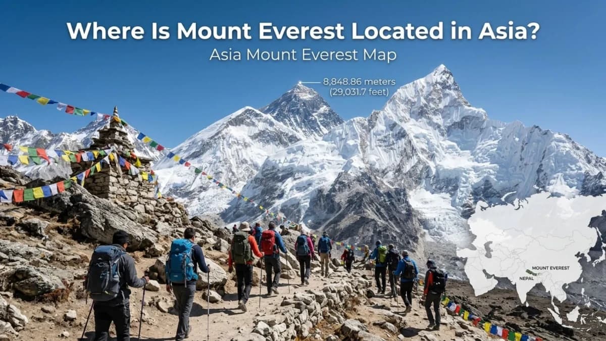
The exact coordinates of Mount Everest are 27.9881° N, 86.9250° E, placing it in the northeastern part of Nepal and the southern edge of the Tibetan Plateau. At an official height of 8,848.86 meters (29,031.7 feet) above sea level, Everest is the highest point on Earth.
| Attribute | Details |
|---|---|
| Mountain Range | Himalayas (Great Himalayan Range) |
| Sub-range | Mahalangur Himal |
| Countries | Nepal & China (Tibet Autonomous Region) |
| Region in Nepal | Sagarmatha National Park, Khumbu Region |
| Region in China | Tibet Autonomous Region |
| Coordinates | 27.9881° N, 86.9250° E |
| Official Height | 8,848.86 m (29,031.7 ft) |
| Continent | Asia |
| Border Position | Exactly on the Nepal–China border |
| Annual Growth | Approximately 4 mm per year |
Mount Everest is not just the tallest mountain in the world - it is also one of the most geographically unique peaks on Earth because the summit lies exactly on an international border shared by two countries.
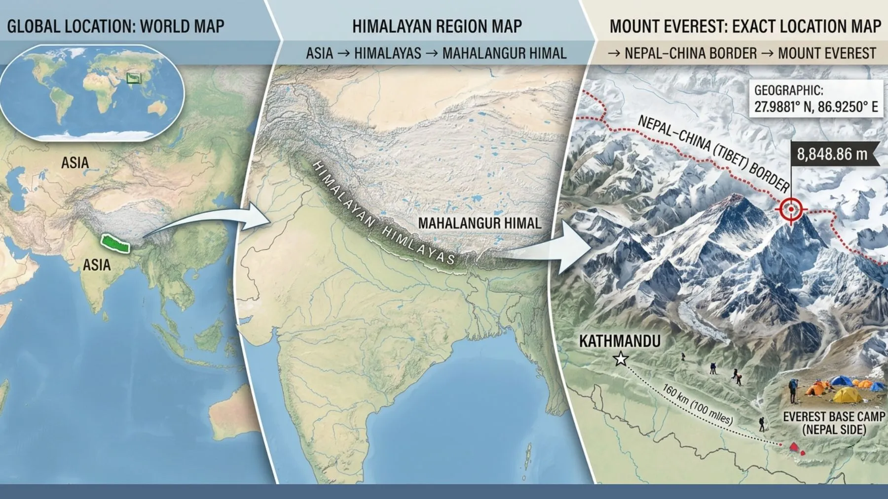
Mount Everest is located in Asia, within the Himalayan mountain range, which stretches about 2,400 km across South Asia. More specifically, Everest lies in the Mahalangur Himal sub-range, the highest section of the Himalayas and home to several of the world’s tallest mountains.
The mountain stands exactly on the international border between Nepal and the Tibet Autonomous Region of China. The southern side lies in Nepal’s Khumbu region inside Sagarmatha National Park, while the northern side extends into Tibet near Tingri County.
Everest’s exact coordinates are 27.9881° N, 86.9250° E, placing it around 150 km northeast of Kathmandu and along the southern edge of the Tibetan Plateau, often called the “Roof of the World.”
In simple terms:
🌎 Asia → 🏔️ Himalayas → ⛰️ Mahalangur Himal → 📍 Nepal–China Border → 🏔️ Mount Everest (8,848.86 m)
Also read: Truth About Dead Bodies on Mount Everest
Mount Everest is located in both Nepal and China. The summit sits exactly on the international border between Nepal and the Tibet Autonomous Region of China, meaning both countries share the world’s highest mountain.
| Side | Country | Local Name | Access |
|---|---|---|---|
| South Side | Nepal | Sagarmatha | Most popular |
| North Side | China (Tibet) | Chomolungma / Qomolangma | Less used |
The southern route through Nepal is used by around 70% of climbers and trekkers because of its well-developed trekking infrastructure, Sherpa villages, and the famous Everest Base Camp Trek. The northern Tibet side is less crowded and accessed mainly by road through the Tibetan Plateau.
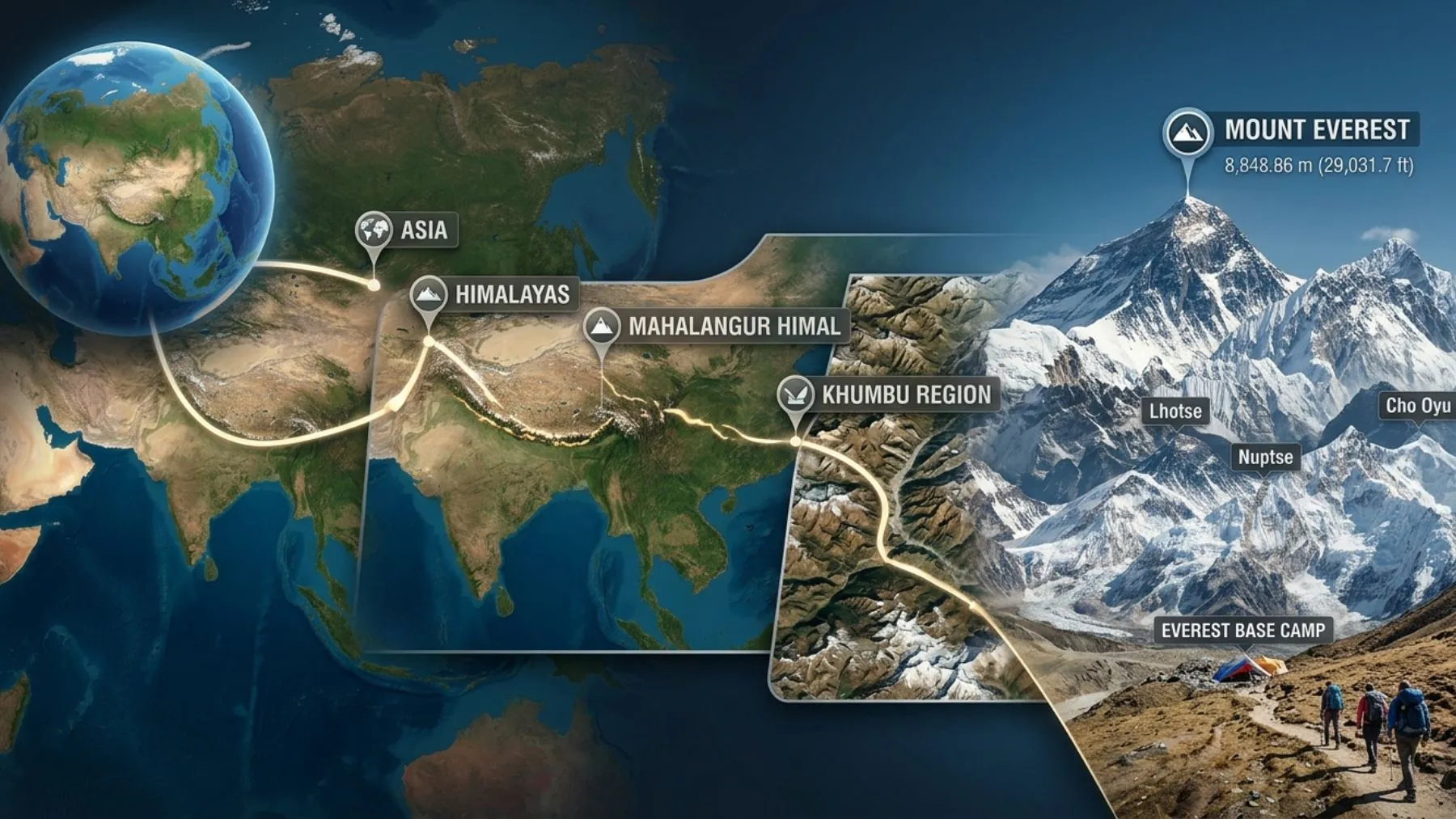
Mount Everest is located in Asia, within the massive Himalayan mountain system, which stretches for around 2,400 km across several South Asian countries. More specifically, Everest lies in the Mahalangur Himal, the highest sub-range of the Himalayas, covering approximately 5,200 square kilometers across northeastern Nepal and southern Tibet.
Inside this region, Everest is part of the famous Khumbu Himal area, alongside major peaks such as Lhotse (8,516 m), Cho Oyu (8,188 m), and Nuptse (7,861 m). The mountain itself stands at coordinates 27.9881° N, 86.9250° E and reaches an official elevation of 8,848.86 meters (29,031.7 feet) above sea level, making it the highest point on Earth.
The exact coordinates of Mount Everest are 27.9881° N, 86.9250° E, placing it on the border between Nepal and Tibet in the central Himalayas. In the more precise DMS format used in official surveys, Everest is located at 27°59′17″ N, 86°55′31″ E.
To find Mount Everest on Google Maps, simply open Google Maps or Google Earth, enter the coordinates 27.9881, 86.9250 in the search bar, and zoom into the Himalayan range between Nepal and China. The map will usually display the peak as Mount Everest, Sagarmatha, or Qomolangma, depending on the map language and region settings.
On the Nepal side, Mount Everest is located inside Sagarmatha National Park, a UNESCO World Heritage Site established in 1976 and covering around 1,148 sq km in the Khumbu region of northeastern Nepal. This region is home to famous trekking settlements and Sherpa communities.
The nearest major city is Kathmandu (1,350 m), followed by Lukla (2,860 m), which serves as the main trekking gateway to Everest. From Lukla, trekkers pass through Namche Bazaar (3,440 m), the largest Sherpa town and the main acclimatization hub of the Everest region.
On the Tibet side, Everest lies within the Tibet Autonomous Region of China, specifically in Tingri County under Xigaze Prefecture. The northern approach leads to the famous North Base Camp (5,150 m) near Rongbuk Monastery, the world’s highest monastery.
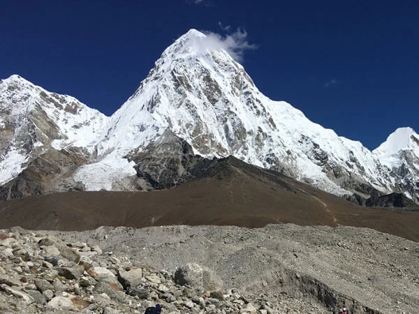
Mount Everest has two main base camp approaches: the South Base Camp in Nepal and the North Base Camp in Tibet (China).
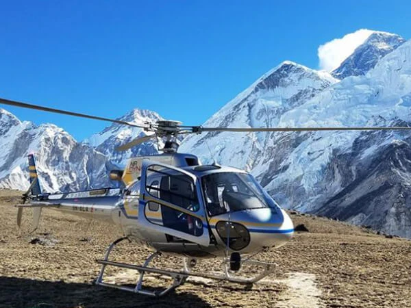
The South Base Camp is located in Nepal at an elevation of 5,364 m (17,598 ft) inside Sagarmatha National Park. It is the most popular route, used by around 70% of climbers and trekkers. Reaching this base camp usually requires a 30–45 minute flight to Lukla followed by an 8–12 day trek through the Khumbu Valley via Namche Bazaar, Tengboche, and Gorakshep.
The North Base Camp lies in Tibet at 5,150 m (16,900 ft) and is accessed mainly by road from Lhasa across the Tibetan Plateau. This route is less crowded and follows the famous Northeast Ridge Route, but it has more limited infrastructure and no helicopter rescue options on the mountain.
Together, these two routes show how Mount Everest is geographically shared between Nepal and Tibet while offering two very different experiences for climbers and travelers.
Recommended: Is Annapurna Part of Everest?
Mount Everest is jointly shared by Nepal and China, as the international border between the two countries runs directly through the summit of the mountain. The southern face of Everest belongs to Nepal, while the northern face lies in the Tibet Autonomous Region of China.
Both countries manage their own sides separately, including climbing permits, tourism infrastructure, environmental protection, and expedition regulations. This shared ownership was formally recognized under the 1961 Nepal–China boundary agreement.
You may also like: MICE Tourism in Nepal
Many people mistakenly believe Mount Everest is in India, but this is incorrect. Everest lies entirely on the border between Nepal and the Tibet Autonomous Region of China, with no part of the mountain inside Indian territory.
Another common misunderstanding is that Everest is completely in Nepal or completely in China. In reality, the summit sits exactly on the international border, meaning both countries share the mountain. The southern side, including the famous Everest Base Camp Trek route, is in Nepal, while the northern face and North Base Camp (5,150 m) are located in Tibet, China.
Don't Miss: Francys Arsentiev– The Tragic Story of Everest
Mount Everest formed due to the collision between the Indian tectonic plate and the Eurasian tectonic plate around 50 million years ago. As the Indian plate continued pushing northward beneath Asia, the Earth’s crust folded and rose upward, creating the Himalayan mountain range.
This tectonic movement is still active today, which is why Everest continues to grow by approximately 4 mm every year. Interestingly, rocks near Everest’s summit contain ancient marine fossils, showing that this region was once beneath an ancient ocean called the Tethys Sea millions of years ago.
Mount Everest’s location is unique because it is the highest point on Earth, standing at 8,848.86 meters (29,031.7 feet) above sea level in the heart of the Himalayas. Unlike most mountains, the summit lies exactly on an international border, shared by Nepal and China (Tibet), making it both a geographic and geopolitical landmark.
The region also holds deep cultural significance. In Nepal, Everest is called Sagarmatha, meaning “Head of the Sky,” while in Tibet it is known as Chomolungma, meaning “Goddess Mother of the World.” For Sherpa and Tibetan Buddhist communities, the mountain is considered sacred rather than just a climbing destination.
Worth reading:Top 10 Best Winter Treks in Nepal
Inspired by the location of the world’s highest mountain? With Recreation Holidays, you can experience the Everest region beyond just reading about it. From the iconic Everest Base Camp Trek to the scenic Everest View Trek and challenging Everest Three Passes Trek, we offer professionally guided adventures across the Himalayas.
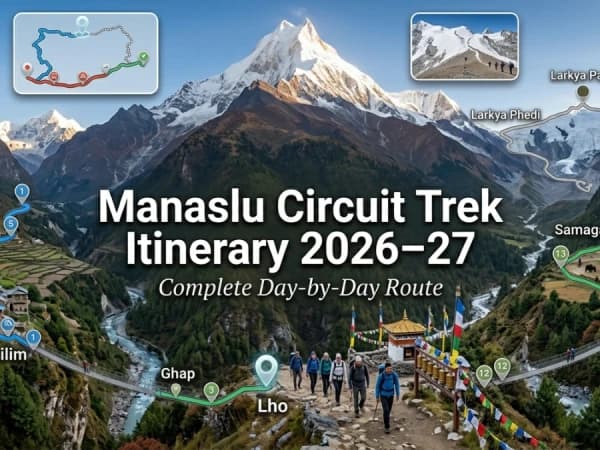
Along with Everest region treks, we also organize some of Nepal’s most popular journeys, including the Annapurna Base Camp Trek, Mardi Himal Trek, Langtang Valley Trek, Manaslu Circuit Trek, Poon Hill Trek, and Gosaikunda Trek.
With experienced local guides, carefully designed itineraries, and personalized service, Recreation Holidays helps you explore Nepal safely, comfortably, and authentically.
Explore unforgettable Everest region journeys with Recreation Holidays today.
Explore Everest AdventuresMount Everest is located in the Himalayas, directly on the border between Nepal and Tibet (China), making it not only the highest mountain on Earth but also one of the most geographically and culturally significant places in the world. From its exact coordinates (27.9881° N, 86.9250° E) to its position inside the Mahalangur Himal and Sagarmatha National Park, Everest represents far more than just a peak—it is a symbol of adventure, nature, and human ambition.
Whether you are interested in geography, trekking, mountaineering, or simply learning about the world’s tallest mountain, understanding Everest’s location helps you appreciate why it remains one of the most iconic destinations on the planet.
And if you dream of experiencing the Everest region in real life, Recreation Holidays offers unforgettable Himalayan journeys, including the Everest Base Camp Trek, Everest View Trek, Everest Three Passes Trek, and many other adventures across Nepal.
Other Related Blogs You May Missed
Annapurna Base Camp vs Everest Base Camp Trek
15 Amazing Things to do in Nepal
Who Cleans Mount Everest's Garbage?
Reasons to Visit Upper Mustang in Nepal
Mount Everest is located in the Khumbu region of northeastern Nepal, inside Sagarmatha National Park.
Mount Everest is located in both Nepal and China (Tibet Autonomous Region) because the summit lies on the international border.
Mount Everest is located in Asia, within the Himalayan mountain range on the Nepal–China border.
Mount Everest is located on the continent of Asia.
Yes, the southern side of Mount Everest is located in Nepal, while the northern side lies in Tibet, China.
Mount Everest is 29,031.7 feet (8,848.86 meters) tall.
Mount Everest has an elevation of approximately 8.85 kilometers above sea level.
The official height of Mount Everest is 8,848.86 meters above sea level.