One of the most common questions trekkers ask is: How many days do you need for the Manaslu Circuit Trek? The answer depends on your fitness level, acclimatization requirements, trekking experience, and available time. While some trekkers complete the 11 Day Manaslu Circuit Trek, others prefer 14, 16, or longer itineraries that include additional acclimatization and side trips.
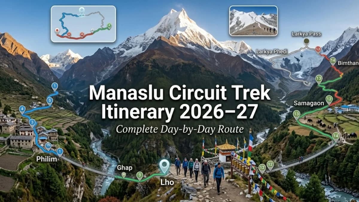
This Manaslu Circuit Trek Itinerary covers the complete Manaslu Circuit Route, including daily route progression, trekking hours, altitude gain, village highlights, acclimatization strategy, and the crossing of Larkya La Pass (5,106m). Whether you're planning a shorter trek or searching for the Best Manaslu Circuit Trek Itinerary, this guide helps you choose the most suitable route.
Manaslu Circuit Trek Itinerary Summary
| Day |
Route |
Altitude |
Distance |
Walking Hours |
| Day 1 |
Drive Kathmandu → Machha Khola |
930m |
~160 km Drive |
8–10 hrs |
| Day 2 |
Machha Khola → Jagat |
1,340m |
~22 km |
6–7 hrs |
| Day 3 |
Jagat → Deng |
1,860m |
~20 km |
6–7 hrs |
| Day 4 |
Deng → Namrung |
2,630m |
~19 km |
6–7 hrs |
| Day 5 |
Namrung → Samagaon |
3,530m |
~18 km |
6–7 hrs |
| Day 6 |
Acclimatization Day at Samagaon |
3,530m |
Optional Hikes |
3–7 hrs |
| Day 7 |
Samagaon → Samdo |
3,875m |
~8 km |
3–4 hrs |
| Day 8 |
Samdo → Dharamsala |
4,460m |
~7 km |
3–5 hrs |
| Day 9 |
Dharamsala → Larkya La Pass (5,106m) → Bimthang |
3,590m |
~20–24 km |
8–10 hrs |
| Day 10 |
Bimthang → Dharapani |
1,860m |
~18 km |
6–7 hrs |
| Day 11 |
Drive Dharapani → Kathmandu |
1,400m |
~220 km Drive |
8–10 hrs |
Trek Statistics at a Glance
| Item |
Details |
| Trek Duration |
11 Days |
| Highest Point |
Larkya La Pass (5,106m) |
| Trek Distance |
Approx. 177 km |
| Starting Point |
Machha Khola (930m) |
| Ending Point |
Dharapani (1,860m) |
| Accommodation |
Tea Houses |
| Difficulty |
Moderate to Challenging |
| Average Walking Hours |
5–7 Hours Daily |
| Longest Trekking Day |
Day 9 (8–10 Hours) |
| Required Permits |
MRAP, MCAP & ACAP |
| Guide Requirement |
Mandatory |
| Best Seasons |
Spring & Autumn |
Understanding the Manaslu Circuit Trek Route
Where Does the Trek Begin?
The classic Manaslu Circuit Route begins at Machha Khola (930m) after a long overland journey from Kathmandu. The trail follows the Budhi Gandaki River through subtropical forests, suspension bridges, and traditional mountain settlements.
Where Does the Trek End?
Most itineraries conclude at Dharapani (1,860m) in the Annapurna region after crossing Larkya La Pass (5,106m) and descending through the alpine landscapes of Bimthang.
Which Districts Does the Trek Pass Through?
The Manaslu Trek Route traverses Gorkha District before entering the high-altitude Nubri region and eventually connecting with Manang District after the pass crossing. Much of the route lies within the Manaslu Conservation Area, while the final section enters the Annapurna Conservation Area.
Why Is Manaslu Considered Nepal's Best Alternative to Annapurna?
Unlike the heavily trafficked Annapurna Circuit, Manaslu Circuit Trek Nepal remains a Restricted Area Trek Nepal, requiring special permits and a licensed guide. The route offers fewer crowds, stronger Tibetan cultural influences, remote mountain villages, and a more authentic wilderness trekking experience.
What Makes Larkya La Pass So Special?
At 5,106m, Larkya La Pass is the highest point of the trek and the defining feature of this renowned Larkya La Pass Trek. The crossing typically requires 8–10 hours of trekking, beginning before sunrise to avoid strong afternoon winds. From the pass, trekkers enjoy panoramic views of Manaslu (8,163m), Himlung Himal, Cheo Himal, Kang Guru, and Annapurna II, making it one of the most spectacular high-altitude passes in the Himalayas.
Manaslu Circuit Trek Itinerary (11 Days)
Our 11 Day Manaslu Circuit Trek Itinerary is designed for trekkers who want to complete the full Manaslu Circuit Route efficiently without missing the trek's major highlights. Covering approximately 177 km, this itinerary passes through remote Himalayan villages, follows the Budhi Gandaki Valley, and crosses the spectacular Larkya La Pass (5,106m) before descending into the Annapurna region.
Day 1: Drive from Kathmandu to Machha Khola
The journey begins with a scenic drive west of Kathmandu through Dhading and Gorkha districts. The route follows winding mountain roads, terraced hillsides, river valleys, and traditional villages before reaching Machha Khola. Although this is a driving day, it provides the first glimpse of the remote landscapes that characterize the Manaslu Circuit Trek Nepal. Overnight accommodation is in a local tea house beside the Budhi Gandaki River.
| Details |
Information |
| Start Point |
Kathmandu (1,400m) |
| End Point |
Machha Khola (930m) |
| Driving Duration |
8–10 Hours |
| Distance |
Approx. 160 km |
| Accommodation |
Tea House |
Day 2: Trek from Machha Khola to Jagat
The trail follows the Budhi Gandaki River through a combination of stone staircases, forest paths, and suspension bridges. Along the way, you'll pass Khorlabesi, the natural hot springs of Tatopani, and several riverside settlements before reaching Jagat. While the altitude gain is moderate, the frequent ascents and descents make this a physically active day. Jagat serves as an important checkpoint on the Manaslu Trek Route, marking the entrance to the higher mountain region.
| Details |
Information |
| Start Altitude |
930m |
| End Altitude |
1,340m |
| Trek Distance |
Approx. 22 km |
| Walking Hours |
6–7 Hours |
| Elevation Gain |
+410m |
| Difficulty |
Moderate |
Day 3: Trek from Jagat to Deng
Today's route enters the restricted section of the Manaslu Circuit Trek Route. The trail passes traditional Gurung settlements, crosses several suspension bridges, and traverses steep sections above the Budhi Gandaki Gorge. As you gain altitude, the valley narrows and the surroundings become increasingly rugged. Deng is a small mountain village where trekkers begin to notice stronger Tibetan cultural influences and a more remote Himalayan atmosphere.
| Details |
Information |
| Start Altitude |
1,340m |
| End Altitude |
1,860m |
| Trek Distance |
Approx. 20 km |
| Walking Hours |
6–7 Hours |
| Elevation Gain |
+520m |
| Difficulty |
Moderate |
Day 4: Trek from Deng to Namrung
This is one of the most important transition days of the Manaslu Trek Itinerary. The route climbs steadily through forests and mountain villages as the landscape gradually shifts from lower Himalayan terrain to the culturally rich Nubri region. Mani walls, chortens, prayer flags, and traditional stone houses become increasingly common. Namrung also offers some of the first clear mountain panoramas, making it a significant milestone on the journey toward Larkya La Pass.
| Details |
Information |
| Start Altitude |
1,860m |
| End Altitude |
2,630m |
| Trek Distance |
Approx. 19 km |
| Walking Hours |
6–7 Hours |
| Elevation Gain |
+770m |
| Difficulty |
Moderate–Challenging |
Day 5: Trek from Namrung to Samagaon
One of the most rewarding days of the entire Manaslu Trek Daily Itinerary, the trail passes through Lho (3,180m) and Shyala before reaching Samagaon, the largest settlement on the circuit. The higher altitude brings dramatic views of Mount Manaslu (8,163m), Himalchuli, Ngadi Chuli, and surrounding glaciers. Samagaon plays a crucial role in the Manaslu Trek Altitude Profile, providing an ideal location for acclimatization before entering the high-altitude zone toward Samdo, Dharamsala, and the Larkya La Pass crossing.
| Details |
Information |
| Start Altitude |
2,630m |
| End Altitude |
3,530m |
| Trek Distance |
Approx. 18 km |
| Walking Hours |
6–7 Hours |
| Elevation Gain |
+900m |
| Difficulty |
Moderate–Challenging |
Day 6: Acclimatization Day at Samagaon
This acclimatization day is a critical component of the Manaslu Circuit Trek Itinerary. Above 3,500m, the risk of Acute Mountain Sickness (AMS) increases significantly, making proper altitude adaptation essential before ascending toward Samdo, Dharamsala, and Larkya La Pass. Following the "climb high, sleep low" principle, trekkers can hike to Pungyen Gompa (4,050m), Birendra Lake (4,200m), or Manaslu Base Camp (4,800m) before returning to Samagaon for the night. This strategy improves acclimatization, enhances oxygen adaptation, and increases the likelihood of a successful pass crossing later in the trek.
| Details |
Information |
| Altitude |
3,530m |
| Activity |
Acclimatization & Exploration |
| Walking Hours |
3–7 Hours (Optional Hikes) |
| Difficulty |
Easy–Moderate |
Day 7: Trek from Samagaon to Samdo
The route gradually climbs through open alpine terrain as the tree line disappears and the landscape becomes increasingly barren. The trail passes yak grazing areas, glacial streams, and traditional settlements influenced by Tibetan culture. Samdo is one of the highest permanent Manaslu Trek Villages and historically served as an important trading point between Nepal and Tibet. The relatively short trekking day supports continued acclimatization within the overall Manaslu Trek Altitude Profile.
| Details |
Information |
| Start Altitude |
3,530m |
| End Altitude |
3,875m |
| Trek Distance |
Approx. 8 km |
| Walking Hours |
3–4 Hours |
| Elevation Gain |
+345m |
| Difficulty |
Moderate |
Day 8: Trek from Samdo to Dharamsala
Although relatively short, this is one of the most important preparation days of the 11 Day Manaslu Circuit Trek. The route climbs steadily toward Dharamsala, also known as Larkya Phedi, the final stop before the pass. At this altitude, oxygen levels are significantly lower than at sea level, and trekkers often notice slower walking speeds and increased fatigue. Proper hydration, nutrition, and rest are essential before the longest and most demanding day of the trek.
| Details |
Information |
| Start Altitude |
3,875m |
| End Altitude |
4,460m |
| Trek Distance |
Approx. 7 km |
| Walking Hours |
3–5 Hours |
| Elevation Gain |
+585m |
| Difficulty |
Moderate–Challenging |
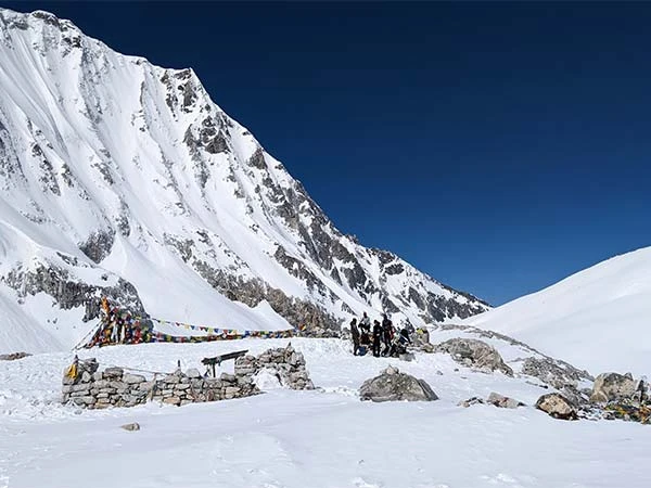
Day 9: Cross Larkya La Pass (5,106m) and Trek to Bimthang
This is the defining day of the entire Manaslu Circuit Route and the highlight of this renowned Larkya La Pass Trek. Most trekkers leave Dharamsala between 3:00 and 4:00 AM to take advantage of stable morning conditions. The climb to the pass follows glacial moraines, snow-covered slopes, and exposed high-altitude terrain before reaching the prayer-flag-covered summit of Larkya La at 5,106m.
From the pass, trekkers are rewarded with panoramic views of Manaslu (8,163m), Himlung Himal (7,126m), Cheo Himal (6,820m), Kang Guru (6,981m), Larke Peak (6,249m), and Annapurna II (7,937m). Strong winds, freezing temperatures, and altitude make this the most physically demanding day of the Manaslu Trek Daily Itinerary, but it is also the most rewarding.
| Details |
Information |
| Start Altitude |
4,460m |
| Highest Point |
Larkya La Pass (5,106m) |
| End Altitude |
3,590m |
| Trek Distance |
Approx. 20–24 km |
| Walking Hours |
8–10 Hours |
| Elevation Gain |
+646m |
| Elevation Loss |
-1,516m |
| Difficulty |
Very Challenging |
Day 10: Trek from Bimthang to Dharapani
After the challenges of Larkya La Pass, the trail descends through rhododendron forests, pine woodlands, and scenic river valleys. The route gradually leaves the high alpine environment behind and enters the Annapurna region. As altitude decreases, oxygen availability improves noticeably, and many trekkers feel a significant boost in energy and recovery. Dharapani marks the official end of the trekking section of the Manaslu Trek Route.
| Details |
Information |
| Start Altitude |
3,590m |
| End Altitude |
1,860m |
| Trek Distance |
Approx. 18 km |
| Walking Hours |
6–7 Hours |
| Elevation Loss |
-1,730m |
| Difficulty |
Moderate |
Day 11: Drive Back to Kathmandu
The final day follows mountain roads through the Marsyangdi Valley before rejoining the highway back to Kathmandu. After completing one of Nepal's finest Restricted Area Treks, trekkers return with unforgettable memories of remote Himalayan villages, Tibetan Buddhist culture, high mountain landscapes, and the successful crossing of Larkya La Pass, the crown jewel of the Manaslu Circuit Trek Nepal.
| Details |
Information |
| Start Point |
Dharapani (1,860m) |
| End Point |
Kathmandu (1,400m) |
| Driving Duration |
8–10 Hours |
| Transportation |
Private Vehicle / Shared Jeep |
Don’t miss → How Long Is the Manaslu Circuit Trek?
Why This Itinerary Works So Well?
This 11 Day Manaslu Circuit Trek Itinerary is designed to balance efficiency with proper acclimatization. Rather than rushing to higher elevations, the itinerary gradually progresses from Machha Khola (930m) to Samagaon (3,530m) before adding a dedicated acclimatization day. This approach helps reduce the risk of Acute Mountain Sickness (AMS) and improves overall trekking performance.
Daily trekking durations are generally kept between 5–7 hours, with shorter acclimatization days before entering the high-altitude zone. The gradual ascent to Samdo (3,875m) and Dharamsala (4,460m) ensures trekkers are better prepared for the demanding crossing of Larkya La Pass (5,106m). As a result, this itinerary offers one of the best combinations of acclimatization, route efficiency, and trekking comfort, making it an excellent Manaslu Circuit Trek Guide for fit trekkers with limited time.
See also → Manaslu Circuit Trek Cost for 11 Days
Village-by-Village Highlights Along the Route
| Village |
Altitude |
What Makes It Special? |
| Machha Khola |
930m |
Gateway to the trek, riverside setting, traditional tea houses. |
| Jagat |
1,340m |
Official permit checkpoint and entry to the restricted region. |
| Deng |
1,860m |
First strong Tibetan cultural influences and quieter mountain atmosphere. |
| Namrung |
2,630m |
Mani walls, monasteries, and the first major Himalayan views. |
| Samagaon |
3,530m |
Largest village on the route, acclimatization hub, Manaslu Base Camp access. |
| Samdo |
3,875m |
Historic Tibetan trade village with dramatic alpine surroundings. |
| Dharamsala |
4,460m |
Final staging point before Larkya La Pass; limited accommodation. |
| Bimthang |
3,590m |
Spectacular glacial valley with views of Manaslu, Lamjung Himal, and Annapurna peaks. |
Accommodation & Cultural Experience
The Manaslu Trek Villages offer a progressively changing experience as altitude increases. Lower villages feature traditional Gurung culture, while upper settlements such as Namrung, Samagaon, and Samdo reflect strong Tibetan Buddhist traditions. Accommodation throughout the Manaslu Circuit Route is provided in tea houses, with Samagaon generally offering the best facilities, including WiFi, charging services, and a wider food selection. Dharamsala remains the most basic overnight stop due to its high-altitude location and limited infrastructure.
Recommended → Kailash Mansarovar Yatra Cost 2026-27
Daily Difficulty Breakdown
The difficulty of the Manaslu Trek Daily Itinerary increases gradually as trekkers gain altitude and approach Larkya La Pass.
| Day |
Difficulty |
Technical Notes |
| Day 1 |
Easy |
Long drive, no trekking. |
| Day 2 |
Moderate |
Multiple ascents, descents, and suspension bridges. |
| Day 3 |
Moderate |
Longer trekking distance and river crossings. |
| Day 4 |
Moderate |
Significant altitude gain (+770m). |
| Day 5 |
Challenging |
Major altitude increase to 3,530m. |
| Day 6 |
Easy |
Acclimatization and recovery day. |
| Day 7 |
Moderate |
Higher altitude trekking with shorter distance. |
| Day 8 |
Challenging |
Trekking above 4,000m with reduced oxygen levels. |
| Day 9 |
Very Challenging |
Larkya La Pass crossing (5,106m), 8–10 hours trekking. |
| Day 10 |
Moderate |
Long descent with significant elevation loss. |
| Day 11 |
Easy |
Return drive to Kathmandu. |
Hardest Day of the Trek
Day 9 is unquestionably the most demanding day of the Manaslu Circuit Trek Route. Trekkers must ascend from Dharamsala (4,460m) to Larkya La Pass (5,106m) before descending more than 1,500 meters to Bimthang. The combination of altitude, distance, cold temperatures, and long trekking hours makes this the physical and emotional highlight of the entire Larkya La Pass Trek.
Explore Nepal Journeys
Discover Nepal’s Best Trekking and Tour Experiences
Best Time for This Itinerary
The Best Manaslu Circuit Trek Itinerary can be completed in multiple seasons, but weather, visibility, and trail conditions vary significantly throughout the year.
| Season |
Conditions |
Recommendation |
| Spring (Mar–May) |
Stable weather, rhododendron forests, moderate temperatures |
Excellent |
| Autumn (Sep–Nov) |
Clear skies, best mountain visibility, dry trails |
Excellent |
| Winter (Dec–Feb) |
Snowfall above Samdo and Larkya La, colder temperatures |
Experienced Trekkers |
| Monsoon (Jun–Aug) |
Heavy rainfall, landslides, poor visibility |
Not Recommended |
Spring and autumn provide the most reliable conditions for the Manaslu Circuit Route, with daytime temperatures remaining comfortable and the highest probability of safely crossing Larkya La Pass (5,106m). Winter is possible but often involves snow-covered trails and more demanding pass conditions.
Read next → When is The Best Time to Visit Nepal?
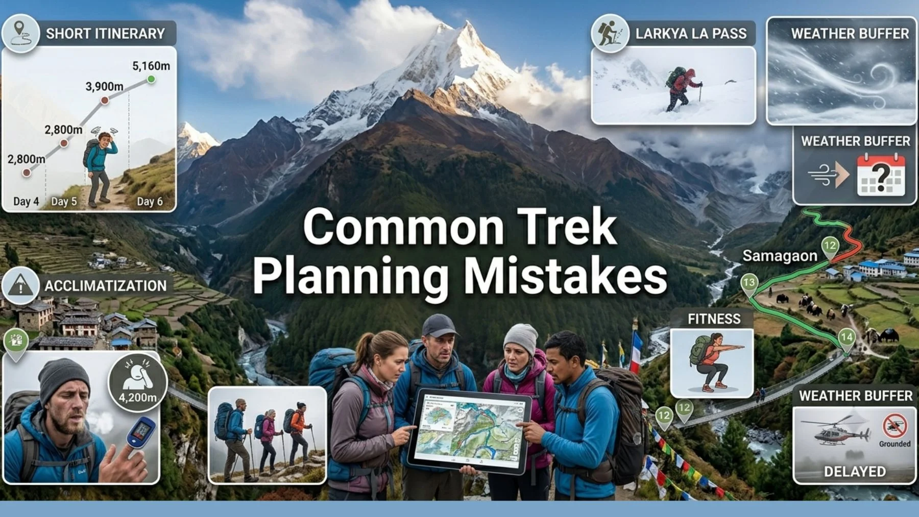
Common Mistakes Trekkers Make When Planning Their Itinerary
Even experienced hikers can make planning mistakes on the Manaslu Trek Route, particularly because it is a remote Restricted Area Trek Nepal.
1. Choosing an Itinerary That Is Too Short
Many trekkers try to complete the circuit too quickly. While an 11 Day Manaslu Circuit Trek is achievable, reducing acclimatization time further can significantly increase altitude-related risks.
2. Ignoring Acclimatization
The ascent from Machha Khola (930m) to Samagaon (3,530m) and eventually Larkya La Pass (5,106m) requires gradual adaptation. Skipping acclimatization days is one of the most common causes of AMS.
3. Underestimating Larkya La Pass
Although technically non-climbing, the pass crossing involves 8–10 hours of trekking, sub-zero temperatures, strong winds, and significant altitude exposure.
4. Poor Physical Preparation
Trekkers should be comfortable walking 15–25 km per day and trekking for multiple consecutive days with sustained elevation gain.
5. Not Accounting for Weather Delays
Road conditions, snowfall, and mountain weather can occasionally affect transport and trekking schedules. A small buffer day is always recommended for longer Manaslu Circuit Trek Nepal plans.
Find out more → Annapurna Base Camp vs Everest Base Camp Trek
Essential Trek Planning Information
| Item |
Details |
| Permits Required |
MRAP (Restricted Area Permit), MCAP & ACAP |
| Guide Requirement |
Licensed guide mandatory |
| Accommodation |
Local tea houses throughout the route |
| Food |
Dal Bhat, noodles, soups, potatoes, Tibetan bread, tea |
| Drinking Water |
Bottled water available; purification tablets recommended |
| Charging Facilities |
Available in most villages for an additional fee |
| Internet Connectivity |
Limited WiFi in larger villages such as Namrung and Samagaon |
| Porter Service |
Available; recommended for carrying heavy trekking gear |
Permits
The Manaslu Circuit Trek is a restricted-area trek requiring three permits: Manaslu Restricted Area Permit (MRAP), Manaslu Conservation Area Permit (MCAP), and Annapurna Conservation Area Permit (ACAP). Independent trekking is not permitted.
Accommodation & Food
Tea houses provide basic twin-sharing rooms, communal dining halls, and freshly prepared meals. Facilities improve in villages such as Samagaon, while Dharamsala (4,460m) offers more limited accommodation due to its remote location.
Guide & Porter Services
A licensed Manaslu Trek Guide is mandatory under current regulations. Many trekkers also hire a porter to carry 15–20 kg of equipment, allowing them to conserve energy for the higher-altitude sections f the Larkya La Pass Trek.
Ready to Follow the Perfect Manaslu Route?
Explore Manaslu Circuit Trek packages with Recreation Holidays and start planning your Himalayan adventure today.
Explore Manaslu Treks
Conclusion
The Manaslu Circuit Trek is one of Nepal's most spectacular trekking adventures, combining remote mountain landscapes, rich Tibetan culture, and the unforgettable crossing of Larkya La Pass (5,106m). Whether you choose an 11-day or extended itinerary, the trek offers a unique and less-crowded Himalayan experience.
💡 You Might Also Like these articles
Nepal Visa Requirements
K2 Mountain Himalayas
Where Is Nepal Located in Asia?
Truth About Dead Bodies on Mount Everest
Francys Arsentiev
Why is Annapurna 3 Unclimbed
Why Choose Recreation Holidays?
Recreation Holidays provides experienced local guides, well-planned itineraries, reliable logistics, and personalized service to ensure a safe and memorable journey. In addition to the Manaslu Circuit Trek, we also offer the Everest Base Camp Trek, Luxury Everest Base Camp Trek, Everest Three Passes Trek, Gokyo Lakes Trek, Everest View Trek, Annapurna Base Camp Trek, Annapurna Circuit Trek, Mardi Himal Trek, Langtang Valley Trek, Ghorepani Poon Hill Trek, and the sacred Kailash Mansarovar Yatra.